Community Corner
New Round of Frigid Cold Headed Toward Batavia
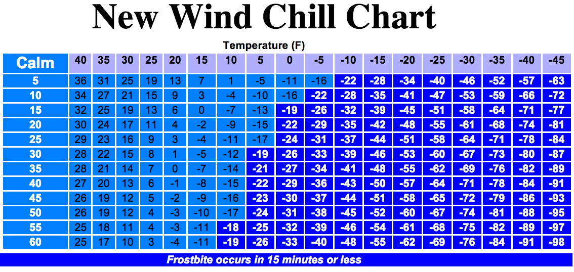
The polar vortex that brought dangerous cold and wind chills to -49 degrees is returning Tuesday, two weeks after it last gripped Batavia.

The more seasonable conditions that visited the area Sunday and which are expected to continue Monday will evaporate Tuesday when the dreaded polar vortex dips south into the Batavia area.
AccuWeather says expect temperatures in the 20s and a blanket of snow late Monday, temperatures will plummet. Dress warmly for single digit highs on Tuesday, in the teens on Wednesday and back to single digits on Thursday. Overnight lows will be below zero, but the gusty winds that made the last polar vortex so dangerous should not be a factor Tuesday. An Alberta clipper at midweek may bring more snow and wind chills.
Check out the full forecast above or visit the AOL Weather page for more information on this week's weather forecast for Batavia.
Find out what's happening in Bataviawith free, real-time updates from Patch.
Let Patch save you time. Have local stories delivered directly to your inbox with our free newsletter. Sign up for Batavia Patch. Then like us on the Batavia Patch’s Facebook page, and follow us on Twitter at @BataviaPatch.
Find out what's happening in Bataviawith free, real-time updates from Patch.
Get more local news delivered straight to your inbox. Sign up for free Patch newsletters and alerts.