Politics & Government
Get Out the Map: State Holds Hearing on Redistricting in Aurora
Roughly 70 people turn out to give input on the new legislative district map, which Democrats will draw this year.


Politics is a funny thing. You think you have a handle on it, and then every 10 years, everything changes.
It’s called redistricting, and though it seems like a dry legislative process, it could mean that your state and federal representatives will change, as could your community’s chances of being heard in Springfield and Washington, D.C.
Once each decade, after the official U.S. Census numbers are released, the map of the country is essentially redrawn. Federal and state legislative districts are reshaped and re-molded to fit the new population data. In theory, this gives each resident and each racial group equal representation in Congress and in the state legislature.
Find out what's happening in Bataviawith free, real-time updates from Patch.
In practice, however, redistricting often serves to benefit the political party that redraws the maps, a trend that has left some residents—and some legislators—frustrated.
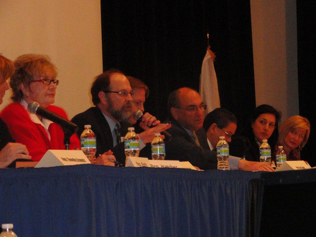
The 2011 redistricting process has been underway for some time, with lawmakers organizing meetings across the state to gather suggestions for the new maps. On Monday, the State House version of the traveling show hit the Illinois Mathematics and Science Academy in Aurora, led by Rep. Lou Lang, D-Skokie, head of the House Redistricting Committee.
Find out what's happening in Bataviawith free, real-time updates from Patch.
With him were local representatives Darlene Senger, R-Naperville; Linda Chapa LaVia, D-Aurora; Kay Hatcher, R-Yorkville; Tim Schmitz, R-Batavia; Mike Fortner, R-West Chicago; Edward Acevedo, D-Chicago; and Pam Roth, R-Morris. For nearly two hours Monday, they listened to ideas, pleas and thoughts about the process, but offered no responses.
Big changes afoot
The 2011 redistricting could see significant changes in the map, particularly in the Fox Valley. The state gained more than 410,000 new residents since 2000, while losing one seat in Congress. But while Chicago’s population decreased, the suburbs saw a large uptick. Kane, Kendall and Will numbered among the five fastest-growing counties in the state.
The Aurora-Naperville area, which includes smaller suburbs like Montgomery, saw nearly 50,000 new residents since 2000. While the black and Asian populations grew somewhat, the Hispanic population in this area increased by more than 32 percent.
Legislators on Monday heard from key members of the local Hispanic community, including Rene Cruz, head of the Aurora Hispanic Chamber of Commerce, and Kane County Board Member Jesse Vazquez, who represents part of Montgomery. Their message was clear: Keep the Hispanic population together, to give them a stronger voice in Springfield and Washington.
Montgomery Village President Marilyn Michelini spoke on behalf of the village, calling it a “fractured area,” since it is split between House and Senate districts. She said she is concerned that another district may be added to that load, and she would like to see the village’s representation consolidated.
“We need a go-to person,” she said.
Montgomery is in the 14th Congressional District, represented by Rep. Randy Hultgren, R-Winfield. Michelini said that vast district lumps Montgomery together with other areas “with different interests than the one we serve.”
And Michelini raised a concern echoed by many during the course of the two-hour hearing: She wants the legislature to provide the proposed map at least two weeks before it is finalized, so that residents can offer their comments. No proposals were on hand Monday.
Let the sun shine in
Michelini’s request highlighted a question many had about the transparency of the process. Since Democrats hold all three branches of the state government, the new map’s boundaries will be entirely up to them, with little to no input from the other party.
Given that, several speakers—including Art Velasquez, of the League of United Latin American Citizens, and Whitney Woodward, of the Illinois Campaign for Political Reform—asked for the additional step this year of allowing public comment on the proposed map before the legislature votes it through.
At one point, Schmitz made the same request, and wondered about the openness of the hearings. Lang said the process for public review of the maps “has not been determined.”
“As soon as I have an answer, you’ll have an answer,” Lang said.
Aurora Mayor Tom Weisner requested that his city’s nearly 200,000 residents be housed in a single senate district, and divided equally between two house districts. Aurora does not have quite enough residents to form its own senate district—for the 2011 maps, lawmakers are aiming for 217,468 in each, and 108,734 in each house district.
Throughout the redistricting process, residents are invited to submit their maps, showing where they would draw district lines. The only one to take them up on it Monday was Christopher Devane of Naperville, who works for a cartography company.
Devane rolled out his map on stage Monday and boldly pronounced it “the easiest, most logical congressional district map in Illinois history.”
“Anyone in the audience can say which county they live, and in five seconds, I can tell you what congressional district they live in,” he said. “No one can do that with our present map.”
Devane said he would submit his map to Lang and his committee after some “tweaks.”
"Holding their breath"
After the meeting, Hatcher, who represents much of Kendall County, expressed her frustration with the process. Democrats have a firm majority in the House this year, she said, with 64 state representatives—more than the 60 needed to pass any measure. Republicans like Hatcher likely will not be included.
But, she said, they will not be silent.
Kendall County residents, she said, are “holding their breath” to see what shape the new map takes. She said there is no indication that the House committee will stick to county lines, or keep east-west boundaries the same. She said she hopes the committee will give weight to the suggestions they are hearing.
“We will all promote our own input on behalf of our constituents, and encourage them to think about balance and parity in the districts as well,” she said. “But that doesn’t ensure that the final maps will include one single suggestion.”
The House committee plans 14 similar hearings in communities across the state over the next week. Lawmakers have until June 30 to approve a new map. If they do not, an eight-member committee will be formed from their ranks to decide on one. That group will have until Sept. 5, and if they do not agree, a ninth member will be appointed to break the tie.
The latest a new district map will be in place is Oct. 5.
If you would like input on the 2011 redistricting, more information is available at www.ilhousedems.com/redistricting.
Get more local news delivered straight to your inbox. Sign up for free Patch newsletters and alerts.